A fire that destroyed at least six homes after blasting through the San Jacinto Mountains continued to rage through 14,200 acres Wednesday morning, keeping the mandatory evacuations in place for nearby communities.
The Mountain Fire broke out Monday afternoon in steep, rugged terrain on private property just off State Highway 243 near the resort town of Idyllwild, over the mountains and southwest of Palm Springs.
Heavy smoke had spread into the Coachella Valley and Palm Springs area by Wednesday.
At least 2,210 firefighters were battling the blaze, along with 128 fire engines, 16 helicopters, 10 fixed-winaircraft, 36 hand crews, eight water-tenders and 12 bulldozers.
The fire -- at 14,200 acres, or about 22 square miles -- remained at 10 percent containment Wednesday morning, according to an online incident report.
RELATED: Mountain Fire photos | Fierce Fire Season Predicted in SoCal
The firefight had cost $4 million as of Wednesday morning, according to an incident update provided Wednesday morning by the U.S. Forest Service, which manages the San Bernardino National Forest where the Mountain Fire was burning.
Winds blowing from the west had pushed the fire east over the crest of the San Jacinto Mountains and toward an area south of Palm Springs, the update stated. The fire was burning in the steep, rugged terrain covered in dry chaparral and timber in the southern portion of the San Jacinto Wilderness.
"High winds, dry fuels, and steep inaccessible terrain challenged initial attack engines, crews and aircraft all day long," stated the 6 a.m. Wednesday update.
Crews made progress on the north and south flanks of the fire, which had formed two heads and was backing down the south side of the mountain range.
Winds are expected to weaken as the weather changes in coming hours and days, and that should help crews make more gains, the update stated.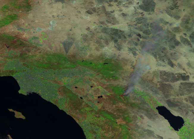
Smoke from the fire could be seen blown some 60 miles to the northeast, across Palm Springs and the Twentynine Palms U.S. Marine Corps training center, a satellite image from the National Oceanic and Atmospheric Administration showed, as seen at left.
In the Bonita Vista area, the fire destroyed six homes, according to a Tuesday report on InciWeb. At Pine Springs Ranch summer camp and retreat, one commercial building, a workshop, garage, and cabin were destroyed. Eleven outbuildings and several cars were also destroyed by the fire.
Resident Lawrence Goda, who lives on unpaved Bonita Vista Road, said neighbors who had been into the burned, still-evacuated area reported his home almost completely destroyed. He said it was a log-cabin-style house he had built nearly 30 years ago -- and it was not insured.
“Everything I worked for all my life is probably up in flames," Goda said.
The scenic area -- the San Bernardino National Forest and adjacent Mount San Jacinto State Park -- is a popular destination for hikers, rock climbers and campers. San Jacinto Peak, the second-highest point in Southern California, is about eight miles north-northeast of where the fire began.
“With the heavy fuels we’ve got and the temperatures we’re experiencing, it’s making it a very aggressive, hot fire right now," Cal Fire spokesman Scott Visyak told NBC4 on Tuesday.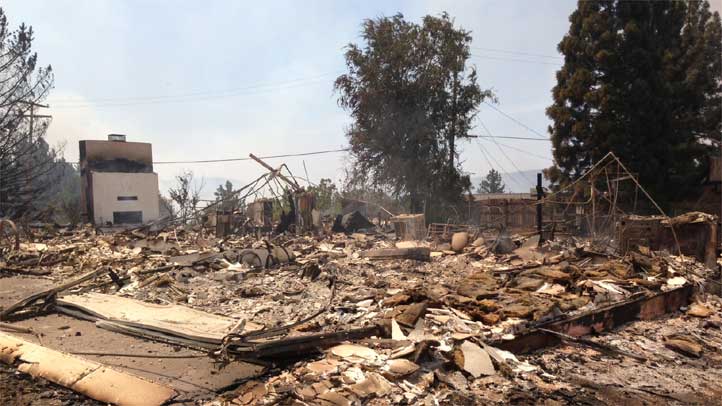
"There’s a disaster area in there. It's devastating. There’s several homes lost, there’s several homes standing. The fire had just gone through there very aggressively," Visyak said.
Mandatory evacuation orders remained in effect Wednesday for the Andreas Canyon Club (south of Palm Canyon Drive in Palm Springs), Bonita Vista, Pine Springs, and the Zen Mountain Center off of Apple Canyon Road.
Camp Ronald McDonald, a charity-funded camp for children with cancer, were voluntarily evacuated due to health concerns related to air quality, as was Camp Joe Sherman.
"All campers have been safely evacuated and returned to their parents and the camp grounds remain out of any immediate danger," said Camp Ronald McDonald Executive Director Sarah Orth in a statement.
The Pacific Crest Trail was closed from State Highway 74 to Saddle Junction, as were the South Ridge Trail, Carumba Trail, Spitler Peak Trail, Fobes Trail, and Cedar Springs, according to an online fire incident report.
Those with day-use or overnight permits for the wilderness area were advised to call the San Jacinto Ranger Station at 909-382-2921.
Highway 243 had reopened by Wednesday morning.
Fire official urged residents to be alert to fire equipment moving on winding local highways, especially during shift changes at 6 a.m. and 6 p.m. They also asked people in the area not to block roadways when trying to view the fire or firefighting work.
Evacuation centers were set up at the following locations:
- Hemet High School, 41701 E. Stetson Ave, Hemet;
- Hamilton High School, 57430 Mitchell Road, Anza;
- and small animals can be brought to the San Jacinto Animal Shelter, 581 S. Grand Ave, San Jacinto.
NBC4 reporters Toni Guinyard and Tony Shin contributed to this report.
More Southern California Stories:
- 12 Arrests in Hollywood Robberies, Vandalism
- Man Killed in Officer-Involved Shooting
- Men Sentenced for Fake Disney Pin Scheme
- Police Ask for Help Finding 21-Year-Old's Killers
- Nail Salons Urged to Ditch Toxic Polish
- Body Found at Park ID'd as Young Father
- Garcetti: Verdict "Will Not Ignite This City"
Photo Credit: Toni Guinyard